Mostrando 1006 resultados
Descripción archivística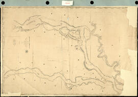
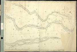
Track Survey of the River Paraná. Sheet N° 6 (Acollarado Island to Mouth of Colastiné). [Levantamiento del trayectos del Río Paraná. Hoja N ° 6 (Isla Acollarado a la Boca de Colastiné).] Impreso.
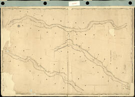
Track Survey of the River Paraná. Sheet N° 7. (Mouth of Colastiné to Latitud 29°55"). [Levantamiento del trayecto del Río Paraná. Hoja N ° 7. (Boca de Colastiné a Latitud 29 ° 55").] Impreso.
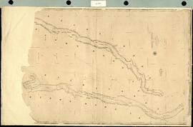
Track Survey of the River Paraná. Sheet N° 9. (Latitud 28° 40' to Guardia Cerrito). [Levantamiento del trayecto del Río Paraná. Hoja N ° 9. (Latitud 28 ° 40 'hasta Guardia Cerrito).] Impreso.
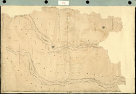
Track Survey of the River Paraná. Sheet N°8. (Latitud 29° 55' to Latitud 28° 40'). [Levantamiento del trayecto del Río Paraná. Hoja N ° 8. (Latitud 29 ° 55 'a Latitud 28 ° 40').] Impreso.
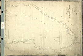
Track Survey of the River Uruguay. Sheet N° 2. [Levantamiento del trayecto del río Uruguay. Hoja N°2.] Impreso.
Track Survey of the River Uruguay with portions of the Rivers Negro and Gualeguaychu. Sheet N° 1. [Levantamiento del trayecto del río Uruguay con porciones de los ríos Negro y Gualeguaychu. Hoja N ° 1.] Impreso.
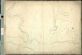
Track Survey of the rivers Salado, Paraná and Colastiné. [Levantamiento del trayecto de los ríos Salado, Paraná y Colastiné.] Impreso.
![Übersichtskarte von Österreich-Ungarn. [Mapa general de Austria-Hungría.]](/uploads/r/archivo-general-de-la-nacion-argentina/f/e/6/fe66178d3d15d620aadc034f7dd974f78f6caf1bdb18b5efa7ca98dbf78ce52e/aragn-MAP-IV-186-625d969b0ac86e219326ef97_142.jpg)
Übersichtskarte von Österreich-Ungarn. [Mapa general de Austria-Hungría.]
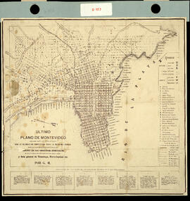
Ultimo plano de Montevideo. Ampliado según los daros oficiales con la delineación proyectada para la novísima ciudad. Indicación de edificos públicos. Límites de las secciones judiciales. Nueva numeración del principio de cada cuadra y Guía General de Tramways, Ferrocarriles, etc. Impreso.
![[Uruguay. Mapa hidrográfico.] Impreso.](/uploads/r/archivo-general-de-la-nacion-argentina/1/5/0/1501db5c87fec1eb930365d66987ebf60137079dd9a1b8775c9553c6cfad9791/aragn-MAP-II-355-625d901c0ac86e219322c5b7_142.jpg)
[Uruguay. Mapa hidrográfico.] Impreso.
Resultados 981 a 990 de 1006