Imprimir vista previa Cerrar
Mostrando 698 resultados
Descripción archivística698 resultados con objetos digitales Muestra los resultados con objetos digitales
Track Survey of the River Uruguay with portions of the Rivers Negro and Gualeguaychu. Sheet N° 1. [Levantamiento del trayecto del río Uruguay con porciones de los ríos Negro y Gualeguaychu. Hoja N ° 1.] Impreso.
Track Survey of the River Uruguay. Sheet N° 2. [Levantamiento del trayecto del río Uruguay. Hoja N°2.] Impreso.
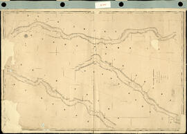
Track Survey of the River Paraná. Sheet N°8. (Latitud 29° 55' to Latitud 28° 40'). [Levantamiento del trayecto del Río Paraná. Hoja N ° 8. (Latitud 29 ° 55 'a Latitud 28 ° 40').] Impreso.
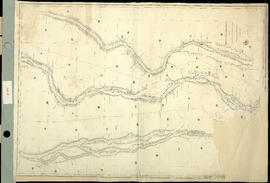
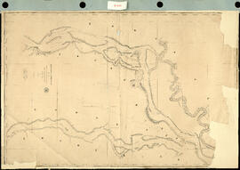
Track Survey of the River Paraná. Sheet N° 9. (Latitud 28° 40' to Guardia Cerrito). [Levantamiento del trayecto del Río Paraná. Hoja N ° 9. (Latitud 28 ° 40 'hasta Guardia Cerrito).] Impreso.
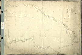
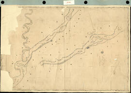
Track Survey of the River Paraná. Sheet N° 7. (Mouth of Colastiné to Latitud 29°55"). [Levantamiento del trayecto del Río Paraná. Hoja N ° 7. (Boca de Colastiné a Latitud 29 ° 55").] Impreso.
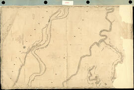
Track Survey of the River Paraná. Sheet N° 6 (Acollarado Island to Mouth of Colastiné). [Levantamiento del trayectos del Río Paraná. Hoja N ° 6 (Isla Acollarado a la Boca de Colastiné).] Impreso.
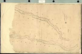
Track Survey of the river Paraná. Sheet N° 5. (Arroyo Soldado to Acollarado Island). [Levantamiento del trayecto del río Paraná. Hoja N ° 5. (Arroyo Soldado a Isla Acollarado).] Impreso.
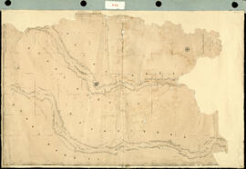
Track Survey of the River Paraná. Sheet N° 4. (Curumbé Island to Arroyo Soldado). [Levantamiento del trayecto del Río Paraná. Hoja N ° 4. (Isla Curumbé a Arroyo Soldado).] Impreso.
Track Survey of the River Paraná. Sheet N° 3. (Paloma Island to Curumbé Island.) [Levantamiento del trayecto del Río Paraná. Hoja N ° 3. (Isla Paloma a Isla Curumbé.).] Impreso.
Track Survey of the River Paraná. Sheet N° 2. Buenos Aires to Paloma Island. [Levantamiento del trayecto del río Paraná. Hoja N°2. Buenos Aires e Isla Paloma] Impreso.
Resultados 11 a 20 de 698